CRM software helps in the visualization of the sales pipeline while also serving as the data hub where sales teams can get the necessary information about potential clients, leads, and opportunities. SugarCRM is one such platform that many businesses use for their needs. One of the best things about Sugar is its flexibility in terms of add-ons that can be used to enhance its functionality by merging the CRM data with useful software tools.
One such add-on that integrates Google Maps with SugarCRM is RT SalesMap. RT SalesMap gives you a visual representation of SugarCRM records on a map using their addresses. Let's see how RT SalesMap enhances sales on SugarCRM.

SugarCRM and Google Maps Integration
RT SalesMap leverages the power of Google Maps in SugarCRM by visualizing your CRM records on a map. You can map any records from any module, including custom modules. You can then use SugarCRM filters to limit the results that are shown on the map. Other than this, you can use the full feature set of Google Maps within SugarCRM including street view which should help you reach your clients more easily.
Filtered Search
Users can apply one or more filters on RT SalesMap when searching for records on the map. To get the locations of Contacts, Leads, or Accounts, users have to specify a module, and then the criteria they want to apply, which can be anything from names to specific city that they might want to search within. The filtered information can even be exported in a CSV file. If users click on a particular pin, a popup appears, in which they can see the record's name. Clicking on the name takes them to the detail view of that record.
Pin Clusters
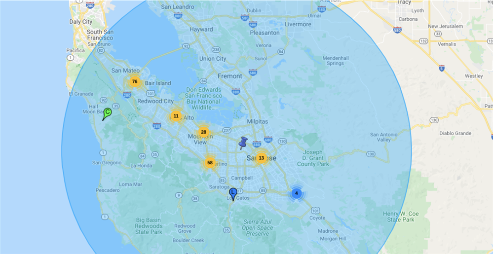
If multiple pins are in close proximity, a zoomed out view shows them as a cluster, with the number of pins in each cluster specified. Zooming in breaks down the cluster into smaller clusters, whereby pins are separated from each other. At the most granular level, there are no clusters, and pins are visible in their individual locations.
Radial Search
Users can enhance the features of Google Maps in SugarCRM with the radial search feature of RT SalesMap. Entering a location into the Postal Address field creates a pin on the map for that location. Then, based on the radius specified in the specific field, users can see a highlighted area on the map which may represent an area of interest. The radius can be set in both kilometers and miles, and for added convenience, with a simple toggle, the results shown can be limited to just those that fall within that radius.
Directions
Salespeople can get directions to a lead or client's location by using the most widely used feature of Google Maps from within SugarCRM. A simple click on the popup over the pin on the map will give users a directed route to the location they want.
Route Planning
Salespeople can not only see where the leads are located, they can plan their route and see how far they'll have to travel for their activities. The route planning feature enables users to add multiple locations to a list, and generate an optimised route based on that.
Location Geo-Coding
RT SalesMap uses the geo-coding technology to convert SugarCRM records' addresses for use in Google Maps. Users can choose if they want to convert street addresses, or use latitude and longitude values already stored in the CRM. Each module can be configured individually, allowing CRM admins to show records on the map without manipulating existing data. If you don't want to change different settings, fields for Accounts, Contacts and Leads are configured by default, so you can get started straight away.
How to get RT SalesMap
If you would like to try RTSalesMap for yourself, you can do so by buying a trial at our SugarOutfitters page. In case of any further queries, feel free to reach out to product.support@rolustech.com.
